
| COUNTRY FACTS: GUINEA | |
|---|---|
| Name(official): | Republic of Guinea |
| Name(short): | Guinea |
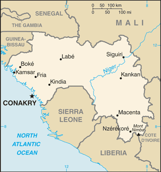
| Capital City: | Conakry |
| Location: | Western Africa, bordering the North Atlantic Ocean, between Guinea-Bissau and Sierra Leone. |
| Coordinate: | 11 00 N, 10 00 W |
| Independence: | (From France) October 2nd; 1958. |
| President: |
|
| Type of Government: | Republic |
| Total Area: | 245 857sq.km. |
| Population: | 9 690 222 (July 2006 est.) |
| People: | Peuhl 40%, Malinke 30%, Soussou 20%, smaller ethnic groups 10%. |
| Religion: | Muslim 85%, Christians 8%, indigenous beliefs 7% |
| Languages: | French (official); note: each ethnic group has its own language. |
| Literacy: | 35.9%total, 49.9%male, 21.9%female (1995 est.) |
| Currency: | Guinean franc (GNF) |
| GDP(per capita): | $2 000 (2005 est.) |
| Arable Land: | 4.47% (2005 est.) |
| Agriculture: | Rice, coffee, pineapples, palm kernels, cassava (tapioca), bananas, sweet potatoes; cattle, sheep, goats; timber. |
| Natural resources: | Bauxite, iron ore, diamonds, gold, uranium, hydropower, fish, salt. |
| Embassy in Japan: | Embassy of the Republic of Guinea, Chancery: 12-9, Hachiyama-cho, Shibuya-ku. Post Code: 150-0035, Tel. 03-3770-4640 |
| General Info: | |
| International Phone Code: | +224 |
ECONOMY: BUSINESS, TRADE AND INVESTMENT
- Tourism:
MAJOR CITIES
Conakry, Nzerekore, Kankan, kindia.
NEWS
INTERNATIONAL ORGANIZATIONS:
GOVERNMENT: ADMINISTRATIVE UNITS
33 prefectures and 1 special zone (zone special)*; Beyla, Boffa, Boke, Conakry*, Coyah, Dabola, Dalaba, Dinguiraye, Dubreka, Faranah, Forecariah, Fria, Gaoual, Gueckedou, Kankan, Kerouane, Kindia, Kissidougou, Koubia, Koundara, Kouroussa, Labe, Lelouma, Lola, Macenta, Mali, Mamou, Mandiana, Nzerekore, Pita, Siguiri, Telimele, Tougue, Yomou.