
| COUNTRY FACTS: LIBYA | |
|---|---|
| Name(official): | Great Socialist People's Libyan Arab Jamahiriya |
| Name(short): | Libya |
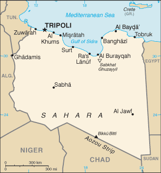
| Capital City: | Tripoli |
| Location: | Northern Africa |
| Coordinate: | 25 00 N, 17 00 E |
| Independence: |
|
| President: |
|
| Type of Government: | Jamahiriya defined by the govt. as "state of the masses" governed by the people through local councils. |
| Total Area: | 1 759 540sq.km. |
| Population: | 5 900 754 (July 2006 est.) |
| People: | Berbers and Arabs 97%, Greeks, Maltese, Italians, Egyptians, Pakistanis, Turks, Indians, Tunisians. |
| Religion: | Sunni muslims 97% |
| Languages: | arabic -primary language, English, French, Italian. |
| Literacy: | 82.6%total, 92.4%male, 72%female (2003 est.) |
| Currency: | Libyan dinar (1LYD =1000dirhams) |
| GDP(per capita): | $8 400 (2005 est.) |
| Arable Land: | 1.03% |
| Agriculture: | Wheat, barley, olives, dates, citrus, vegetables, peanuts, soyabeans, cattles. |
| Natural resources: | Petroleum, natural gas, gypsum. |
| Embassy in Japan: | People's Bureau of the Great Socialist People's Libyan Arab Jamahiriya, Chancery: 10-14, Daikanyama-cho, Shibuya-ku. Post Code: 150-0034, Tel. 03-3477-0701/4 |
| General Info: | |
| International Phone Code: | +218 |
ECONOMY: BUSINESS, TRADE AND INVESTMENT
- Tourism:
MAJOR CITIES
Tripoli, Benghazi.
NEWS
INTERNATIONAL ORGANIZATIONS:
- United Nations
- African Union
- CEN-SAD
- COMESA
- UMA
- NEPAD
GOVERNMENT: ADMINISTRATIVE UNITS
31 municipalities (singular--"shabiya", plural--"shabiyat"): Butnan, Darnah, Gubba, Al Jabal al-Akhdar, Marj, Green Belt, Benghazi, Ajdabiya, Wahat, Kufra, Surt, Al Jufrah, Misurata, Murgub, Bani-waleed, Tarhuna and Msallata, Tripoli, Jfara, Zawiya, Subrata and Surman, An Nuqat al Khams, Gharyan, Mezda, Nalut, Ghdames, Yefren and Jadu, Wadi Alhaya, Ghat, Sabha, Wadi Shati, Murzuq.