
| COUNTRY FACTS: UGANDA | |
|---|---|
| Name(official): | Republic of Uganda |
| Name(short): | Uganda |
| Capital City: | Kampala |
| Location: | Eastern Africa, west of Kenya. |
| Coordinate: | 1 00 N, 32 00 E |
| Independence: | (From Britain) October 9th; 1962 |
| President: | Lt. Gen. Yoweri Kaguta MUSEVENI |
| Type of Government: | Republic |
| Total Area: | 236 040sq.km. |
| Population: | 28 195 754 (July 2006 est.) |
| People: | Baganda 17%, Ankole 8%, Basoga 8%, Iteso 8%, Bakiga 7%, Langi 6%, Rwanda 6%, Bagisu 5%, Acholi 4%, Lugbara 4%, Batoro 3%, Bunyoro 3%, Alur 2%, Bagwere 2%, Bakonjo 2%, Jopodhola 2%, Karamojong 2%, Rundi 2%, non-African (European, Asian, Arab) 1%, other 8%. |
| Religion: | Roman Catholic 33%, Protestant 33%, Muslim 16%, indigenous beliefs 18% |
| Languages: | English (official national language, taught in grade schools, used in courts of law and by most newspapers and some radio broadcasts), Ganda or Luganda (most widely used of the Niger-Congo languages, preferred for native language publications in the capital and may be taught in school), other Niger-Congo languages, Nilo-Saharan languages, Swahili, Arabic . |
| Literacy: | 69.9%total, 79.5%male, 60.4%female (2003) |
| Currency: | Ugandan shilling (UGX) |
| GDP(per capita): | $1 88 (2005) |
| Arable Land: | 21.57% (2005) |
| Agriculture: | coffee, tea, cotton, tobacco, cassava (tapioca), potatoes, corn, millet, pulses, cut flowers; beef, goat meat, milk, poultry. |
| Natural resources: | Copper, cobalt, hydropower, limestone, salt, arable land |
| Embassy in Japan: | Embassy of the Republic of Uganda, Chancery: 9-23, Hatiyama-cho, Shibuya-ku. Post Code: 150-0035, Tel. 03-3462-7107 Emabassy of the Republic of Uganda, Tokyo. |
| General Info: | |
| International Phone Code: | +256 |
ECONOMY: BUSINESS, TRADE AND INVESTMENT
- Bank of Uganda
- Economic Policy Research Center
- Uganda Export Promotion Board
- Public Enterprises Reform and Divestiture Program (PERD)
- Min. of Finance, Planning and Econ. Development (MFPED)
- Uganda Investment Authority (UIA)
- Lake Victoria Free Trade Zone (LVFTZ)
- Tourism: Major tourist destinations includes .....
- Bwindi Impenetrable National Park
- Kibale National Park
- Mgahinga Gorilla National Park
- Murchison Falls National Park (largest in Uganda)
- Queen Elizabeth National Park
- Rwenzori Mountains national Park
- Lake Kyoga
- Lake Victoria (the world's 2nd largest freshwater body)
- Bujagali Falls (ideal for white water rafting, kayaking, high bungee jump etc).
- Uganda Tourist Board
- Uganda Wildlife Authority (UWA)
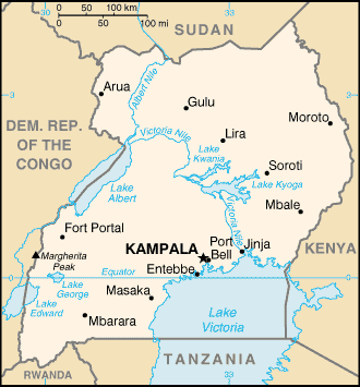
MAJOR CITIES
Arua, Kampala, Entebe, Fort Portal, Jinja, Gulu, Lira, Masaka, Mbale, Mbarara, Moroto, Soroti
NEWS
INTERNATIONAL ORGANIZATIONS:
- United Nations
- African Union
- OIC
- Commonwealth of Nations
- COMESA
- IGAD
- NEPAD
GOVERNMENT: ADMINISTRATIVE UNITS
56 districts; Adjumani, Apac, Arua, Bugiri, Bundibugyo, Bushenyi, Busia, Gulu, Hoima, Iganga, Jinja, Kabale, Kabarole, Kaberamaido, Kalangala, Kampala, Kamuli, Kamwenge, Kanungu, Kapchorwa, Kasese, Katakwi, Kayunga, Kibale, Kiboga, Kisoro, Kitgum, Kotido, Kumi, Kyenjojo, Lira, Luwero, Masaka, Masindi, Mayuge, Mbale, Mbarara, Moroto, Moyo, Mpigi, Mubende, Mukono, Nakapiripirit, Nakasongola, Nebbi, Ntungamo, Pader, Pallisa, Rakai, Rukungiri, Sembabule, Sironko, Soroti, Tororo, Wakiso, Yumbe
Note: As of a July 2005, 13 new districts were reportedly added bringing the total up to 69; the new districts are Amolatar, Amuria, Budaka, Butaleja, Ibanda, Kaabong, Kabingo, Kaliro, Kiruhura, Koboko, Manafwa, Mityana, Nakaseke; a total of nine more districts are in the process of being added.