
| COUNTRY FACTS: BURUNDI | |
|---|---|
| Name(official): | Republic of Burundi |
| Name(short): | Burundi |
| Capital City: | Bujumbura |
| Location: | East Central Africa, within the great lake region. Click to enlarge
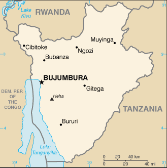 Map of Burundi |
| Coordinate: | 3 30 S, 30 00 E |
| Independence: | (From Belgium) July 1st; 1962 |
| President: | Pierre Nkurunziza |
| Type of Government: | Republic |
| Total Area: | 27 830sq.km. |
| Population: | 8 090 068 (July 2006 est.) |
| People: | Majority are Hutus and Tutsis, and a few Twa(Pygmy), Europeans, Asians. |
| Religion: | Christians 76%, indigenous beliefs 23%, muslims 10%. |
| Languages: | Kirundi and French (official), Swahili. |
| Literacy: | %total, %male, %female |
| Currency: | Burundi franc(1 Burundi franc =100 centimes) |
| GDP(per capita): | $739 (2003 est.) |
| Arable Land: | 35.57% (2005 est.) |
| Agriculture: | Coffee, cotton, tea, beans, banana, sweet potatoes, manioc (tapioca) corn, sorghum, beans and rice |
| Natural resources: | Kaolin, bastnaesite, tin and colombo-tantalite, gold, uranium, cobalt, nickel deposits and platinum deposit not yet exploited |
| Embassy in Japan: |
|
| General Info: | |
| International Phone Code: | +257 |
ECONOMY: BUSINESS, TRADE AND INVESTMENT
- Tourism:
MAJOR CITIES
Bujumbura, Gitega, Muyinga, Ngozi, Ruyigi
NEWS
INTERNATIONAL ORGANIZATIONS:
- United Nations
- African Union
- COMESA
- ECCAS
- NEPAD
GOVERNMENT: ADMINISTRATIVE UNITS
17 provinces, Bubanza, Bujumbura Mairie, Bujumbura Rural, Bururi, Cankuzo, Cibitoke, Gitega, Karuzi, Kayanza, Kirondo, Makamba, Muramvya, Muyinga, Mwaro, Ngozi, Rutana, Ruyigi.